Archive for the ‘Manhattan’ category

Waterfalls in New York City

June 28, 2008

It appears that some Danish/Icelandic artist by the name of Olafur Eliasson set up four waterfalls near Manhattan. I can now attest to two of them. I don’t know about the others.

I went down to the South Street Seaport today to take a look. I had seen the early setup of one of them on the Brooklyn Bridge so I knew where to start looking. Sure enough, there it was on the east side of the Brooklyn Bridge.

It’s a nice waterfall, but it ain’t Niagara. Of course, that’d be way too expensive even for NYC. It looked a bit higher but less wide than the Brooklyn Bridge waterfall.

The second waterfall was on the Manhattan side of the East River.

I wasn’t in the ideal spot for watching. I noticed two variations of watching it. First, just to the south of the waterfall, there seemed to be a viewing area.

You can see by the next picture how good my zoom was for the picture. People were kicking back and relaxing on the third level of the South Street Seaport.

The other great way to see the waterfalls appeared to be by boat. The New York Water Taxi and some tour boats were doing a bang-up business taking people out there.

As I understand it, this will be going on for the next five months or so. Maybe I’ll get over to the other side to see it. But maybe not. Like I said, it’s no Niagara.

-H

Cruising Around Manhattan. Boat Cruise, that is…

June 27, 2008

I recently got the chance to go on a work-related boat cruise around Manhattan (well, actually, only about a third of the way and back) and did have my camera. Being Famous Ankles, I spent a lot of the trip just snapping pictures.

There’s not much of a storyline to the photos, so I’ll be brief. Oh, and I got a lot of pictures. I’ll break it into a number of posts, but I won’t do my usual consecutive postings with “Part 1”, “Part 2” and so-forth. Just the occasional post when I feel like it.

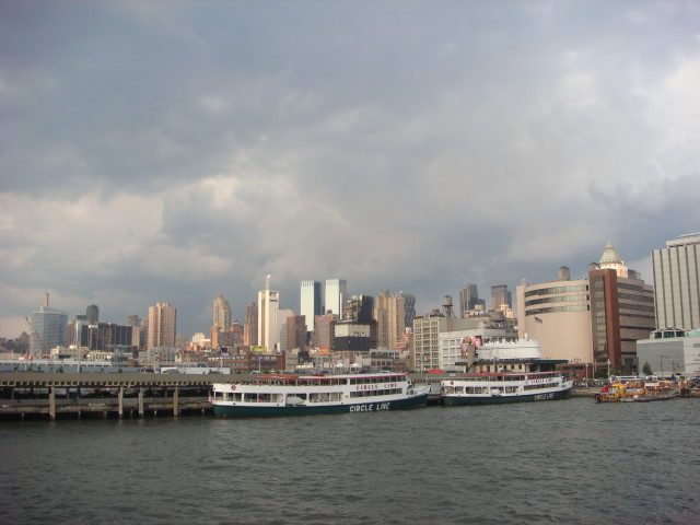
We started off on the World Yacht pier at about 41st and 12th Avenue. No point in describing the boat. It was nice. 

It started by heading north to the Upper West Side. The next picture is still in Mid-Town West, though.

Another Mid-Town West shot (mid-town is in the 30s or so to about 59th Street). This is a view I’ve seen many, many times: kayakers. It is always cool to think about how popular kayaking is on the Hudson River. Of course, with 8 or 10 million people in the NYC area, three kayakers does not a massive trend make.

My old stomping grounds. This is the view of Trump Place. Some of the Trump Place buildings are rental, others are condos. At the far left, the tall building with the circular structure on the top is one of the condo buildings and is one of the more iconic Trump Place buildings.

Here’s a better show with, perhaps, four of the Trump Place buildings. The “iconic” one is on the far left. The third building from the left; the brownish one? That’s my old building. I lived there for a year when I first got to NYC. I was on the 17th floor. That’s about the top of the first level of the building. I was about the second window from the far left. As good as this view is of it; I had a better view: the Hudson and even New Jersey. (For my earlier posts on Trump Place, see here and here.)

Here’s a marina that is just to the north of Trump Place. Incidentally, this is probably around 80th Street if you want to know.

Another shot of the marina.

The highest we got was just north of the marina. I did max out my 5x telescopic lens (built-in) to get this picture of the George Washington Bridge in the distance. I’m surprised it came out as well as it did.

Coming back down the Hudson now. This barge was parked on the river just north of Trump Place. That was something I always loved to see: lots of barges would spend the weekend anchored off here. (Not sarcasm: I really did like seeing them. Some were wonderfully set up and others were somewhat dilapidated. I enjoyed them all. I never did see a human on any of them.)

The sun was starting to go down when I took this next picture. (Okay, okay. I took a lot more in between, but they’re redundant or not as good as the ones I’m showing.) That’s the Empire State Building in the distance. It’s located midway across Manhattan.

I tried to frame this right, but chopped off the top of the Empire State. There were a number of boats on the water, but not as many as the warm Friday night would normally bring out. Probably gas was too expensive.

What can I say? Chelsea Piers at twilight is a good way to describe this next picture. The “frame” on the right part of the picture is the golf driving range.

I took so many variations of this shot! This isn’t the best, but I’ll post another or two at another date. But the view is wonderful. This is southern Manhattan. A few years ago, you’d have seen the twin towers.

Here’s another shot of Chelsea Piers, this time with the Empire State Building in the background. Incidentally, Chelsea Piers is in the 20’s. It’s a bit fuzzy, but I wanted to have the boat in the picture, too.

Last picture for the day: southern Manhattan with a sailboat.

I’ve put a statement in this blog a number of times: if you visit, take the Circle Line Cruise. Take the long one! It goes completely around Manhattan.

-H

307th Infantry Memorial in Central Park

June 26, 2008

Near the clamshell in Central Park (at the level of 69th Street and just to the east of Fifth Avenue) is a war memorial that I have never noticed before.

It’s the World War I memorial to the dead of the 307th Infantry, 77th Division of the Allied Expeditionary Forces from New York. The area is marked, but it is very unobtrusive. There’s a stone with information carved into it. It’s already fading away. But it notes that from 1917 to 1919 there were 590 deaths of officers and men. Yes, WWI only lasted until 1918, but I presume some died of their injuries after the armistice.

The memorial is spread out and really consists of plaques in front of trees.

There’s a second larger stone, more professionally done (and recently cleaned of grafitti) that commemorates the members that were, I guess, masons from the order of the Knights of Pythias.

There are two kinds of plaques. The first is copper and shiny. I didn’t see one that didn’t have some sort of prymarks or damage. One each of these is a list of names of the 590. The names on the different plaques don’t seem to overlap. Each group of soldiers has their own plaque.

The second type of plaque is more brass. This one commemorates the members of the machine gun company who were killed in action. Two sergeants and ten privates in this case.

There’s actually a bit of an overlook of the area nearby. An outcropping of schist and I got a grand overview of it.


Some of the trees that had plaques in front of them have already been removed. Perhaps age, perhaps blight. I don’t know if there are plans to replant, but I would certainly hope so.

-H

T’Other End of 42nd Street

June 21, 2008

In yesterday’s post, I showed the east end of 42nd Street. It’s only fair that I now show the west side of the same street. Balance is restored in the universe. Whew, it was close.

And here it is; the point where 42nd Street drivers would plunge into the Hudson River…providing they weren’t shunted to the side onto 12th Avenue by lots and lots of obstacles.

And the view from 12th Avenue of the intersection.  You may note some of the obstacles starting here.  If nothing else, lots of traffic.  In NYC, you see a lot of drivers push through a red light by following the car in front.  It seems to be nearly a requirement at this intersection.  I saw it more here than at most intersections…and I see it all the time at other intersections.

It’s true that the area doesn’t have a lot of retail.  But apparently it is getting a new entertainment complex.  Yes, bowling comes to NYC.  Okay, okay; there’s lots of bowling in NYC already.  But we’re getting more.

Here’s the other obstacle.  A marina.  Not just any marina, but the Circle Line.   I’ve said it before in this blog:  if you visit NYC, take the Circle Line tour of Manhattan.  In fact, take the longest tour you can and circle the island.  I think it’s about three hours long.  “A three-hour tour”?  Shades of Gilligan’s Island!

Of course, that’s Mid-Town West behind it.  Ain’t New York grand?  I’ll say it is.

-H

The End of 42nd Street

June 20, 2008

42nd Street is one of the most famous streets in all of NYC. (Okay, Broadway and Wall St. have it beat, and maybe 34th Street…and maybe 57th and a few others…)

42nd Street cuts across Manhattan pretty much right in the middle of the island. At the east side (which is what the below picture shows), the street goes right past the United Nations and then plunges into the East River as it tries to link into Queens. Okay, scratch that. It actually merges into FDR Drive which runs north-south.

I was looking at it the other day and just thought it was interesting that the street at this point is really mundane.

-H